Where was Fort Casimir?
Historical and archaeological evidence from the 1986 Heite report
(Old answer: It was across from the
windmill,
( Modern answer: under the parking lot at the end of Chestnut St.))
(Click on images to enlarge)

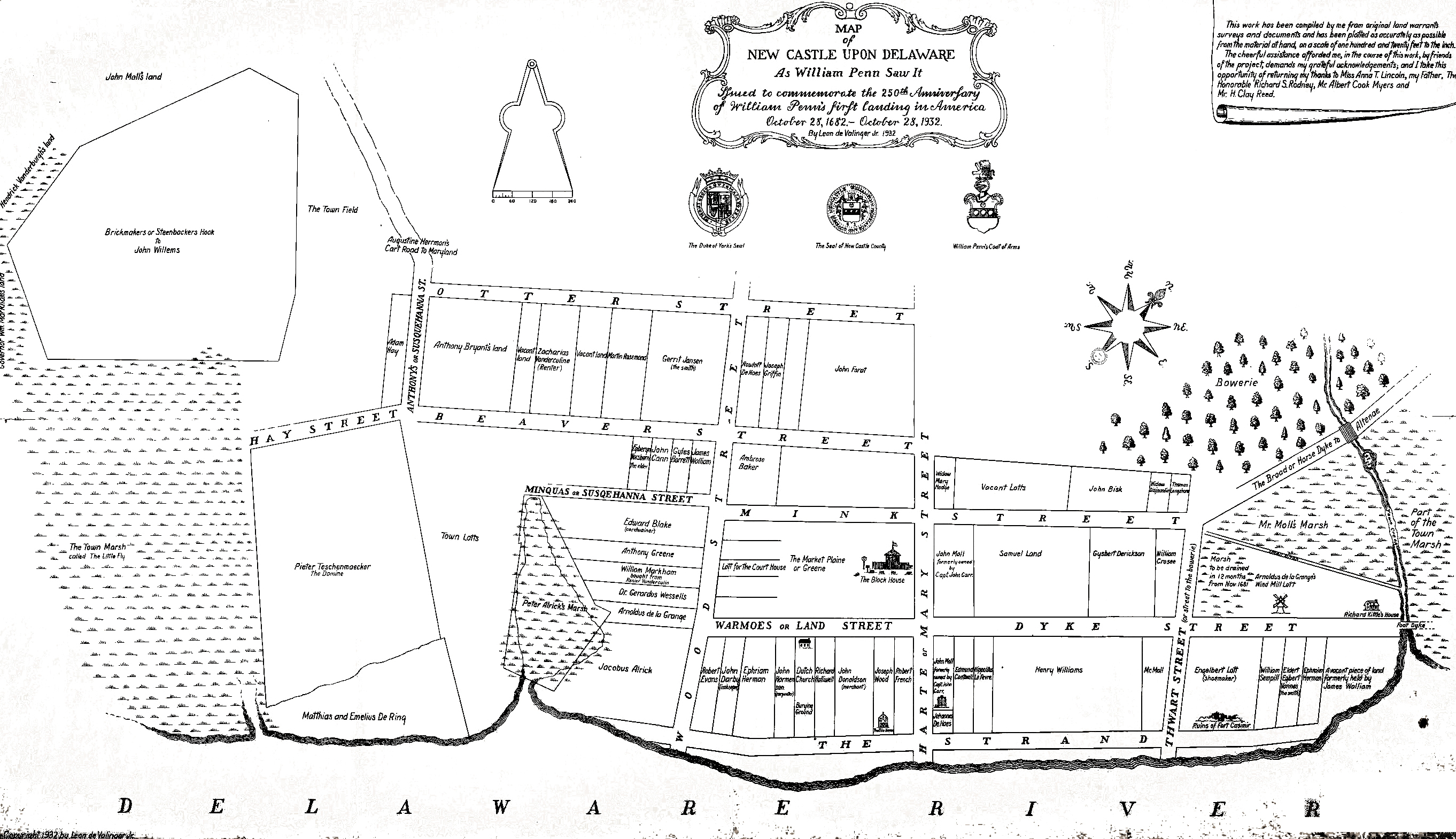
Fort Casimir was the first structure in New Castle. It was built in
1651 on the orders of Dutch governor Peter Stuyvesant of New Amsterdam to
counter the colony planted at the current site of Wilmington by the Swedes
and the former Dutch governor of New Amsterdam Peter Minuit.
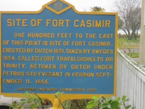
You have probable seen the historical markers near Harmony & 2nd streets
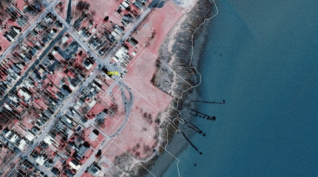 that indicates that Fort Casimir. was "100 ft to the east"
Where is that? (New Castle is not laid out North-South.) How believable is
the statement? The first question is easy to answer -- just click on the
aerial photo to the right-- 100 ft to the east is at the end of the concrete
pavement that led to the ferry (1925-1952).
that indicates that Fort Casimir. was "100 ft to the east"
Where is that? (New Castle is not laid out North-South.) How believable is
the statement? The first question is easy to answer -- just click on the
aerial photo to the right-- 100 ft to the east is at the end of the concrete
pavement that led to the ferry (1925-1952).
An idea of what's under the ground, and what was happening here 330 or so
years ago can be
found in the archaeological report prepared in 1986 by Edward and Louise Heite.
It is available here
in pdf form with the permission of the Trustees of New Castle Commons (2 mb).
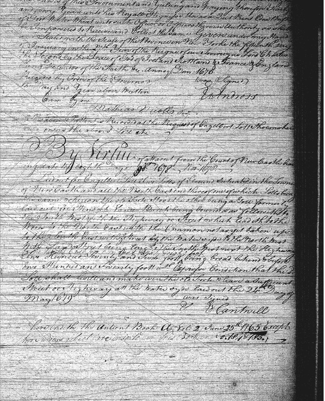
Documentary evidence
They quote an article by Alexander B. Cooper, Esq, written in 1905 for
presentation to the Historical Society of Delaware. (Available
here as a 1.2 mb pdf, see p19) He had discovered a
deed from 1678 which showed that Englebert Lott was granted a deed for a lot
whereon the old fort stood:
|
|
By virtue of a warrant from the Court of New Castle bearing date the eighth day of November, 1678. Laid out for Englebert Lott, two lotts of Ground situated in the towne of New Castle and att the North East end thereof, one of which lotts being the same whereon the Old Forte stood, the other being a lott formerly ...." The actual deed is not particularly easy to read. |
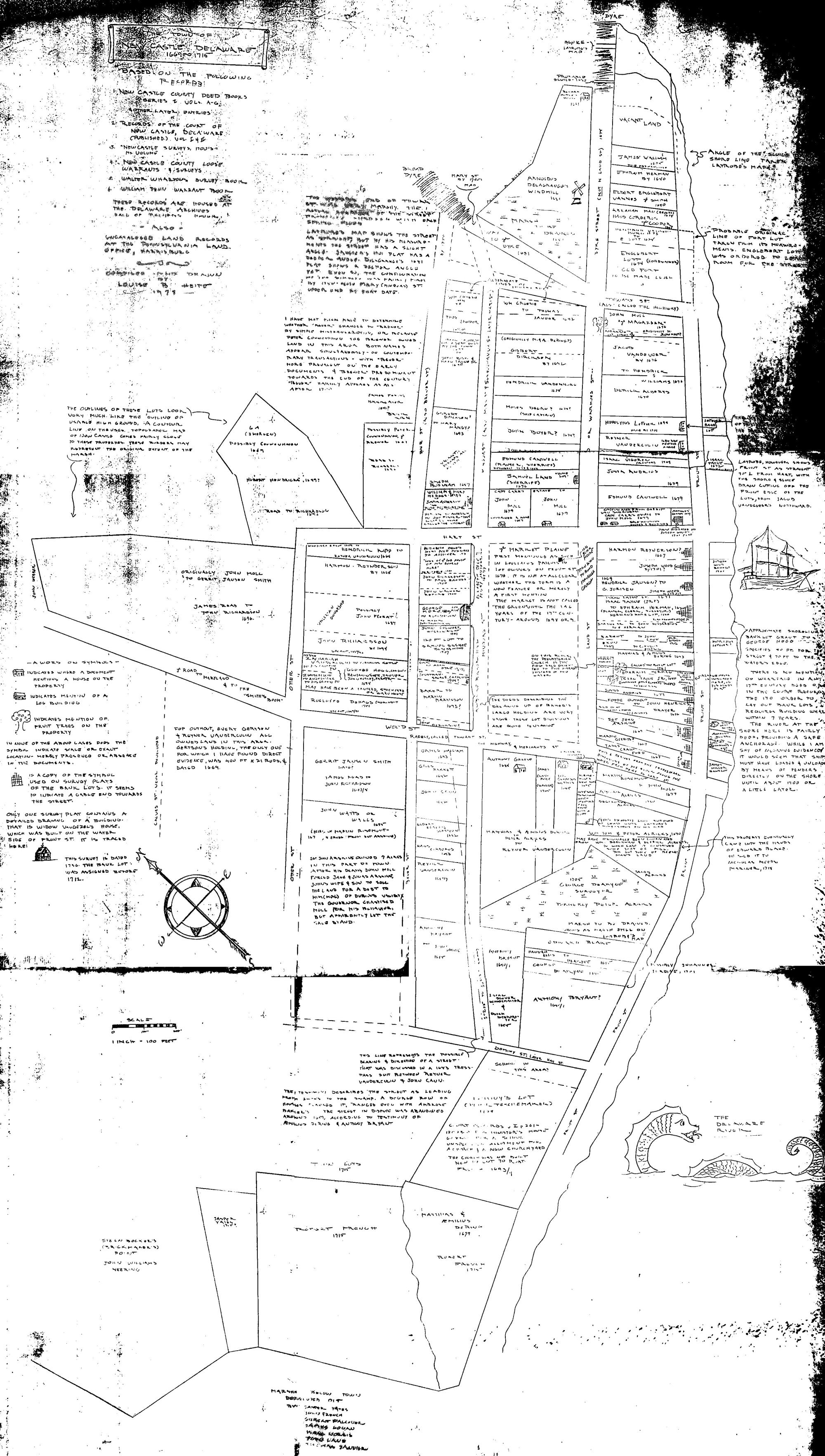
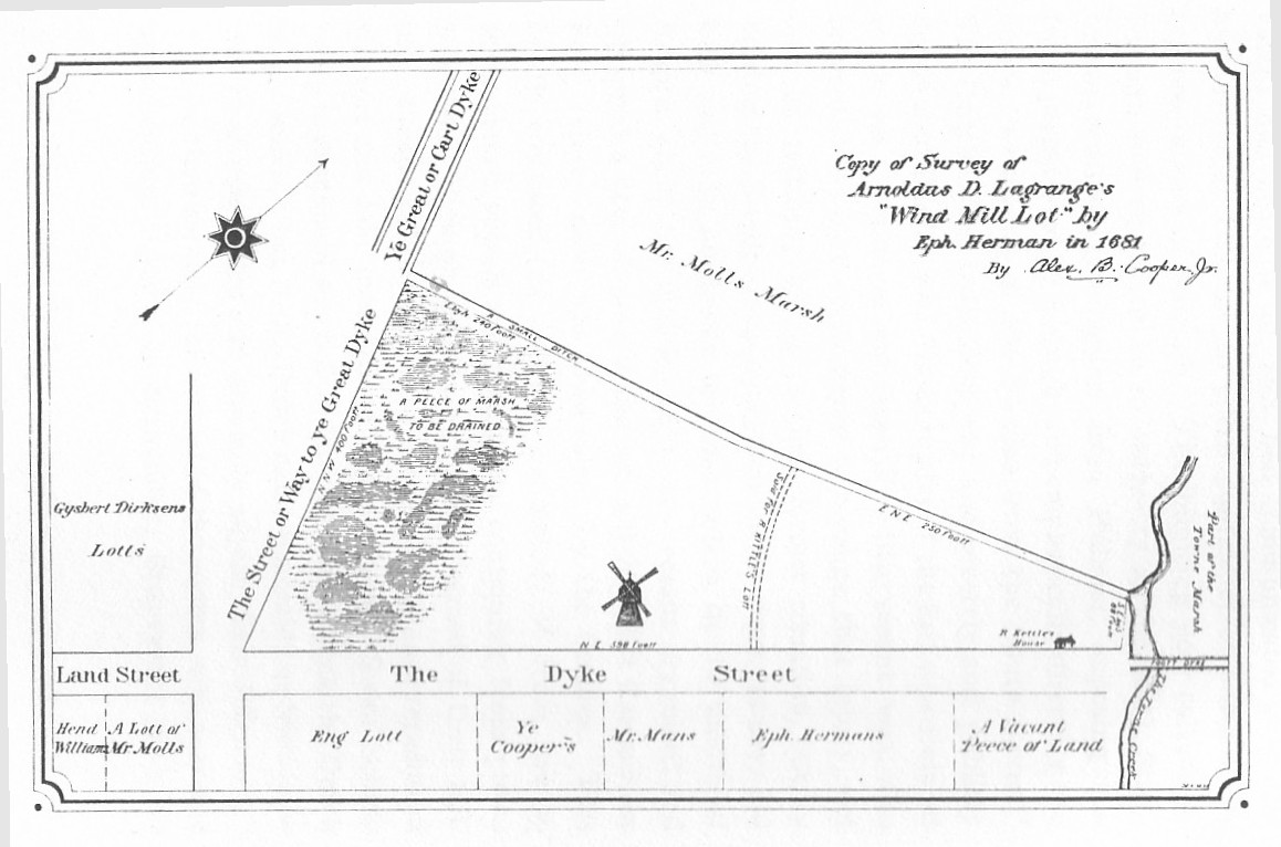 Cooper, an amateur historian living at the time in New Castle, also found a
survey of the Lagrange lot which he redrew and published.
The surveyor, Ephraim Herman, son of Augustine
Herman, included on the survey the location of the windmill and the
Englebert property. Cooper placed Ft. Casimir to the east of the
intersection of second and chestnut streets.
Cooper, an amateur historian living at the time in New Castle, also found a
survey of the Lagrange lot which he redrew and published.
The surveyor, Ephraim Herman, son of Augustine
Herman, included on the survey the location of the windmill and the
Englebert property. Cooper placed Ft. Casimir to the east of the
intersection of second and chestnut streets.
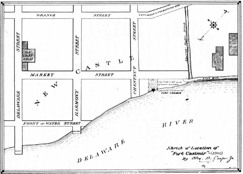 Note that the evidence doesn't say WHERE in the lot the fort was, and Cooper
bases his location partially on speculation on changes in the
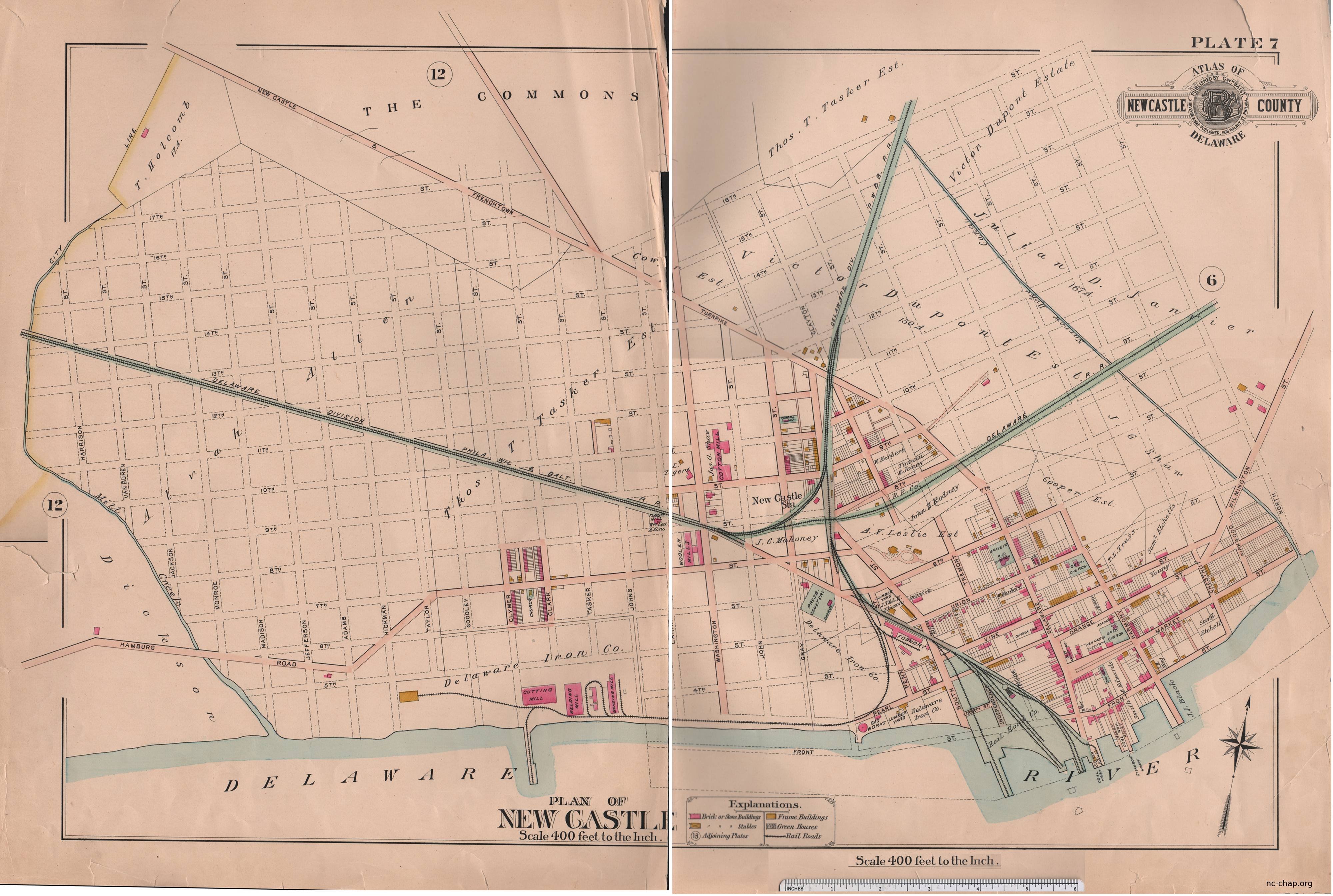
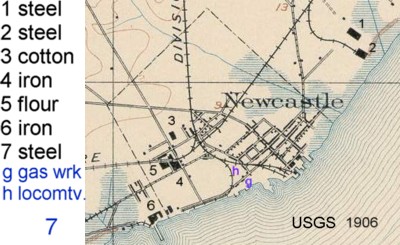
waterfront. (Note in Cooper's 1678 re-drawing 'Ye Great Dyke' and the marsh 'to be drained'.
and the two
steel plants just over the dyke in the 1904 map!)
Note that the evidence doesn't say WHERE in the lot the fort was, and Cooper
bases his location partially on speculation on changes in the
waterfront. (Note in Cooper's 1678 re-drawing 'Ye Great Dyke' and the marsh 'to be drained'.
and the two
steel plants just over the dyke in the 1904 map!)
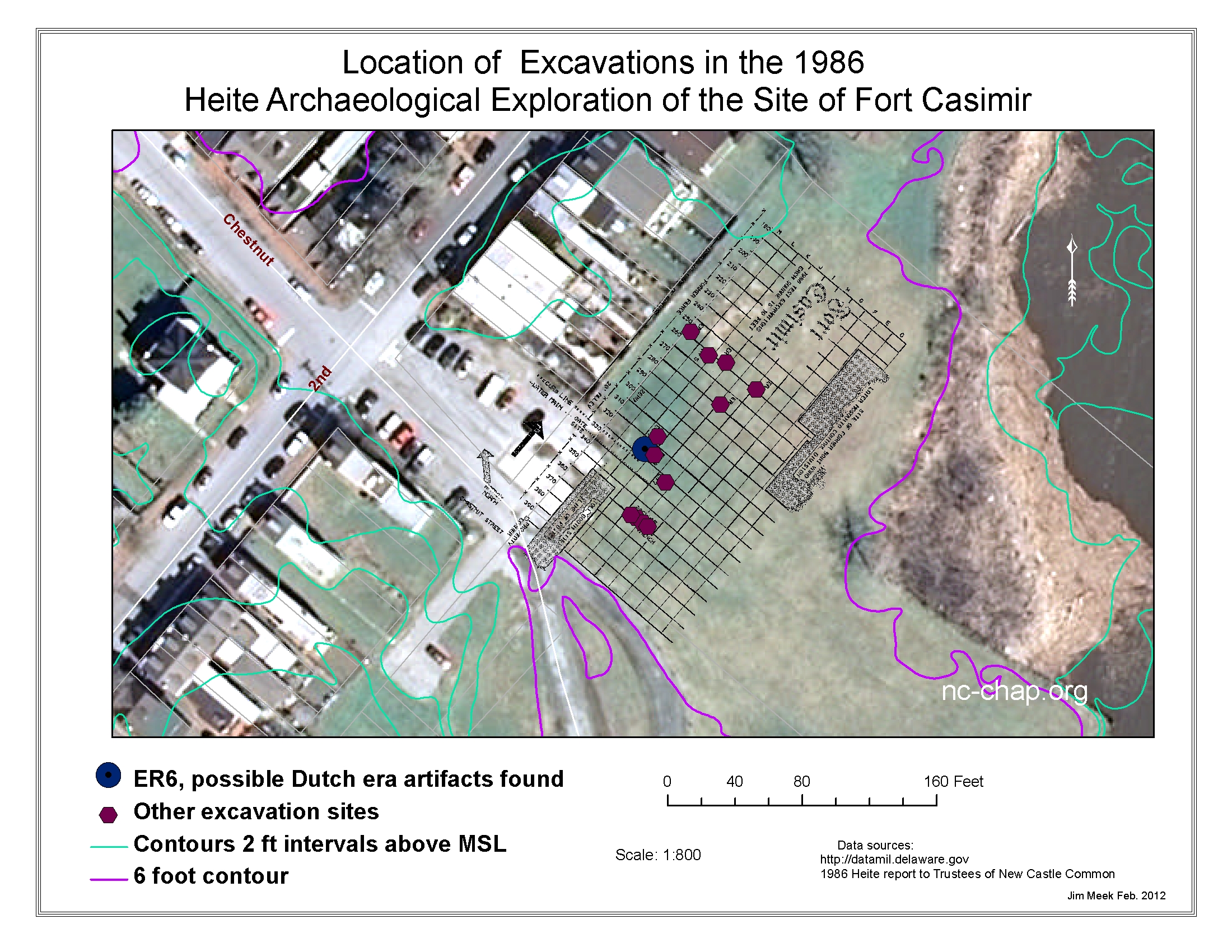
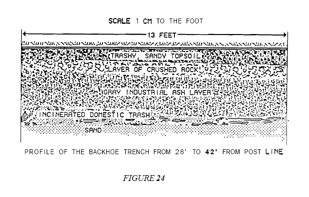 A backhoe trench and
individual units were excavated. All of the excavations had several
feet of paving, industrial trash or fill above undisturbed soil or soil mixed
with early artifacts.
A backhoe trench and
individual units were excavated. All of the excavations had several
feet of paving, industrial trash or fill above undisturbed soil or soil mixed
with early artifacts.
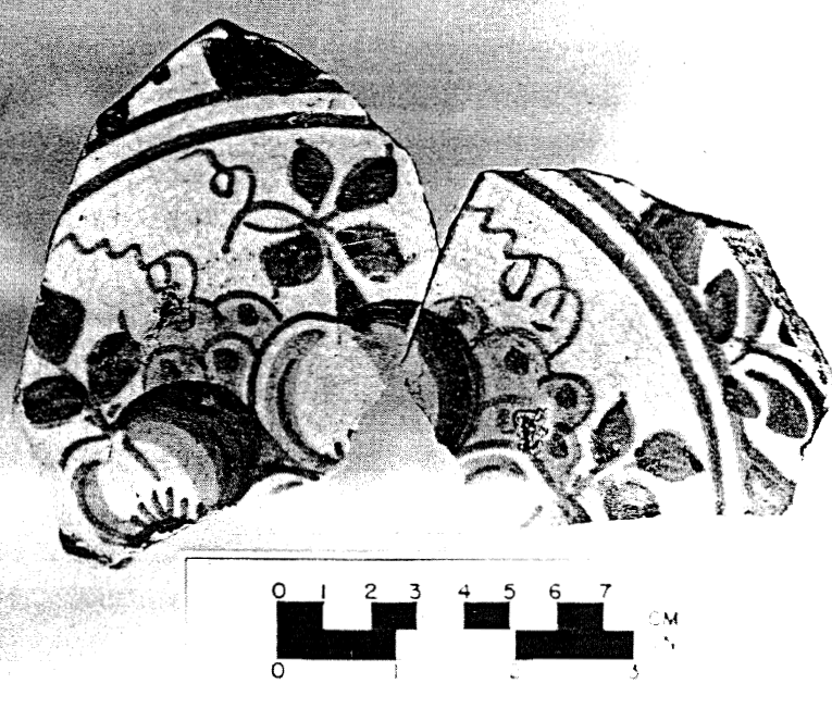 A waterline (date unknown) was detected. They found in a former trench items that might be expected from a
mid-1600's Dutch settlement -- bricks and building tiles that matched samples from the Ft. Orange and
Albany sites, and domestic and decorative ceramics. The pottery found included a piece of majolica decorated
in the style of emperor Wan Lin (1573 -
1619) similar to known Dutch pieces of the time. Also found were gray earthenware vessels similar to that seen in Dutch paintings of the period
and three white clay pipestems with bore sizes likely for that period.
A waterline (date unknown) was detected. They found in a former trench items that might be expected from a
mid-1600's Dutch settlement -- bricks and building tiles that matched samples from the Ft. Orange and
Albany sites, and domestic and decorative ceramics. The pottery found included a piece of majolica decorated
in the style of emperor Wan Lin (1573 -
1619) similar to known Dutch pieces of the time. Also found were gray earthenware vessels similar to that seen in Dutch paintings of the period
and three white clay pipestems with bore sizes likely for that period.
The Heites state (p45):
Fort Casimir has been found. Some of it survives under the "Fort Lot" where Engelbert Lott was required to level it. Of the lot's location there has never been any doubt, and of the fort's appearance there was never any question. However, Bull Hill has changed considerably over the three centuries since the fort was demolished, to the point where the fort's location is not readily apparent in the topography.Probable location of the fort
The features discovered in 1986 are certainly associated with the fort, but we cannot at this point know which part of the fort. The deposits appear to represent a trench with five distinct layers of fill
Some caution may be in order as to whether the Fort has "been found". Certainly early artifacts have been unearthed at a location that is consistent with that known from documentary sources. But a clear proof seems to be lacking, and nothing short of a major excavation of the site and nearby areas now under homes and gardens would be definitive.
Conclusions and cautionary note
The Heites conclude:
It is tempting to suggest that the site be dug immediately. The excavated fort site
would be a significant tourist attraction. Many New Castle residents would certainly rally behind a project to dig the site. However, an archzological project equal to the significance of the site could cost more than a million dollars to execute and could represent a significant permanent commitment to interpretation and preservation as well.We recommend protection rather than excavation for several reasons. First, the site is in no immediate danger; we know where it is, and future generations will be more experienced and better equipped to deal with it. The second reason is the long-term commitment involved in taking care of a developed site and the artifacts recovered from it; such a commitment requires planning, funding, and provision for perpetual care that cannot be accomplished quickly. The third, and perhaps most persuasive reason for not excavating the fort is the fact that there are other sites in New Castle that can potentially reveal as much about the seventeenth century, and that may be in danger of destruction. Endangered sites should always receive priority over sites that are protected