Hidden in plain sight
Remains of the New Castle Gas Co.
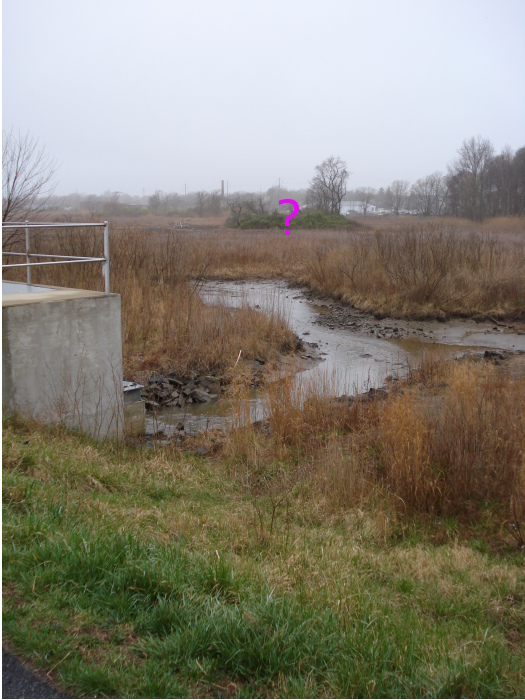
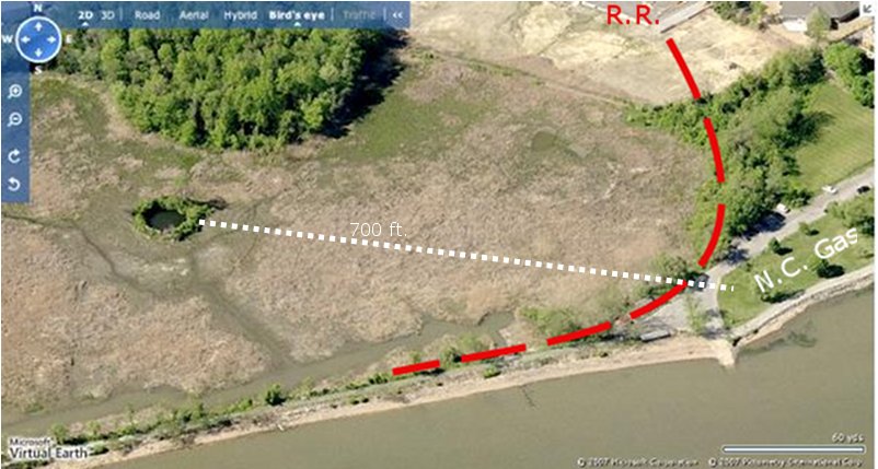
Walkers along the riverfront near
the New Castle sailing club are unlikely to notice a small tree covered mound in
Gambacorta marsh. When the sun strikes it at certain angles, you can see traces of brick.
Only long time residents are likely to know that it's the remanants of the gas
company that supplied New Castle lights from 1857 to 1917. (Click on images to enlarge).
Dick Aplebee recalls being warned to keep away from the gas tank as a child; Don Reese recalls hearing the tank is deep and full of fish. Carl Witt says there was another tank by the boathouse made of metal, and that you can still see its foundation outline at certain times of the year.
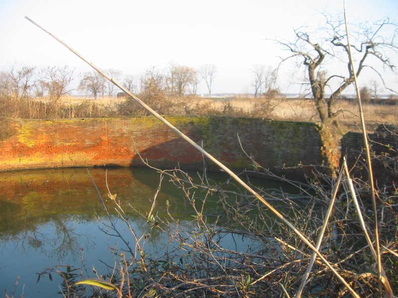
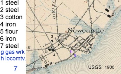
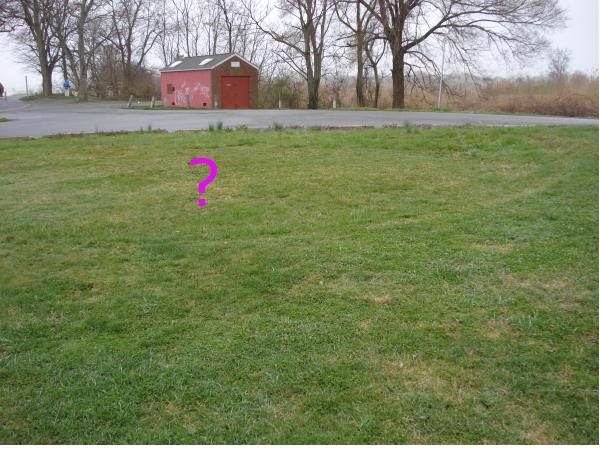
 But would a gas tank be brick? Approaching it from the Gambacorta parking lot, you can see the
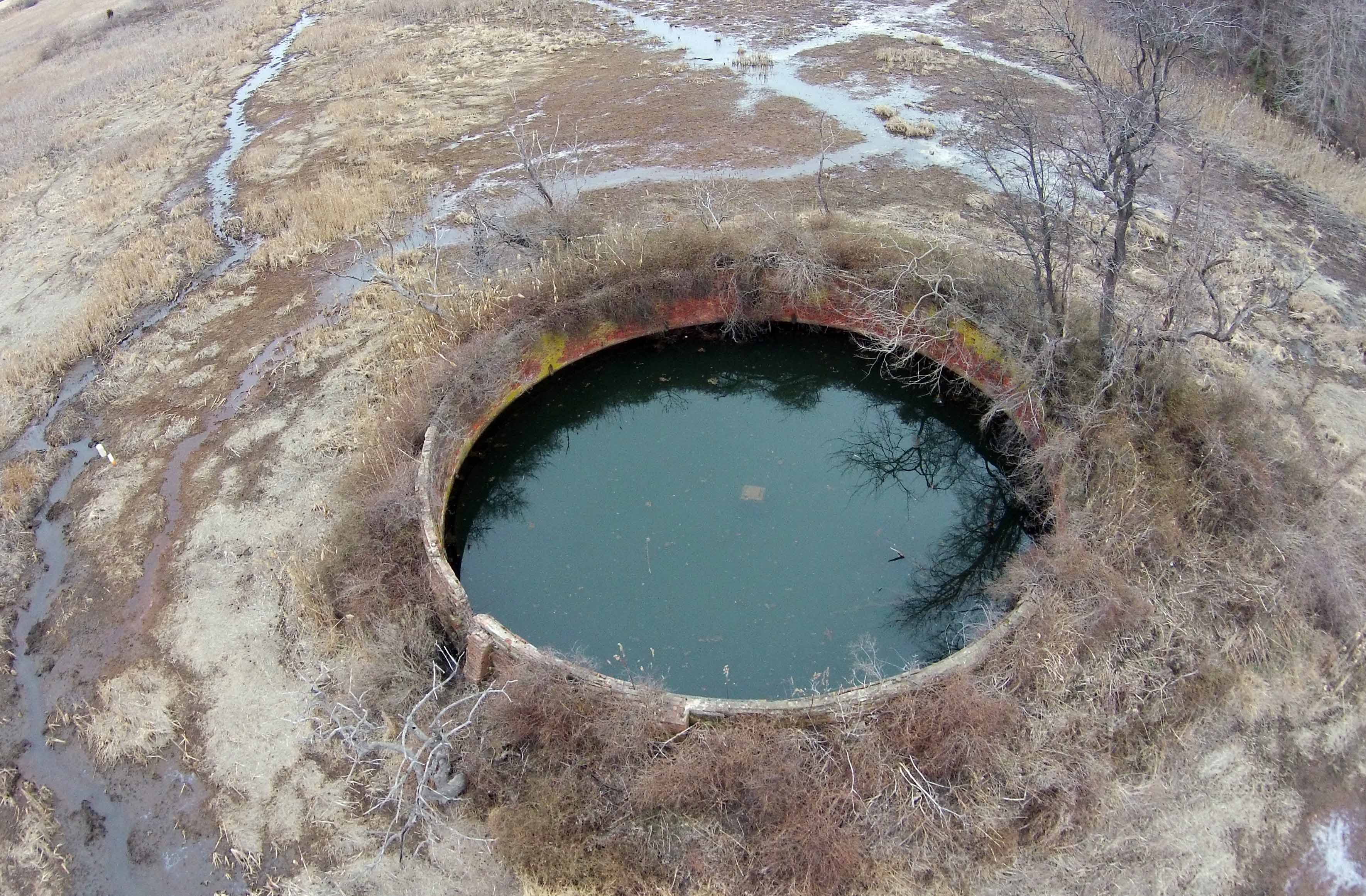
mound is actually a water filled hollow brick cylinder ~30 feet dia, 8 feet above water level, and
currently 6-10 feet water depth. The 6 course thick brick wall is surrounded
by a mound of dirt. Photo by drone by Bruce Burk.
But would a gas tank be brick? Approaching it from the Gambacorta parking lot, you can see the
mound is actually a water filled hollow brick cylinder ~30 feet dia, 8 feet above water level, and
currently 6-10 feet water depth. The 6 course thick brick wall is surrounded
by a mound of dirt. Photo by drone by Bruce Burk.
When was the gas company built?
Where was the plant?
How was gas made? Do toxic chemicals remain?
Was the big brick thing really a gas tank? When was it built?
According to Scharf(1888) the plant was founded in 1857, and according to DNREC was acquired by .... Gas and closed in 1917.
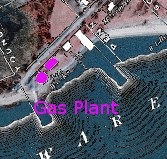 An overlay of the Beers 1868 atlas over a modern aerial photo shows that the gas plant was along the river
at the end of what is now Battery Park.
Shown are a round tank and rectangular building. The map shows nothing in
the adjacent marsh other than (planned?) roads.
An overlay of the Beers 1868 atlas over a modern aerial photo shows that the gas plant was along the river
at the end of what is now Battery Park.
Shown are a round tank and rectangular building. The map shows nothing in
the adjacent marsh other than (planned?) roads.
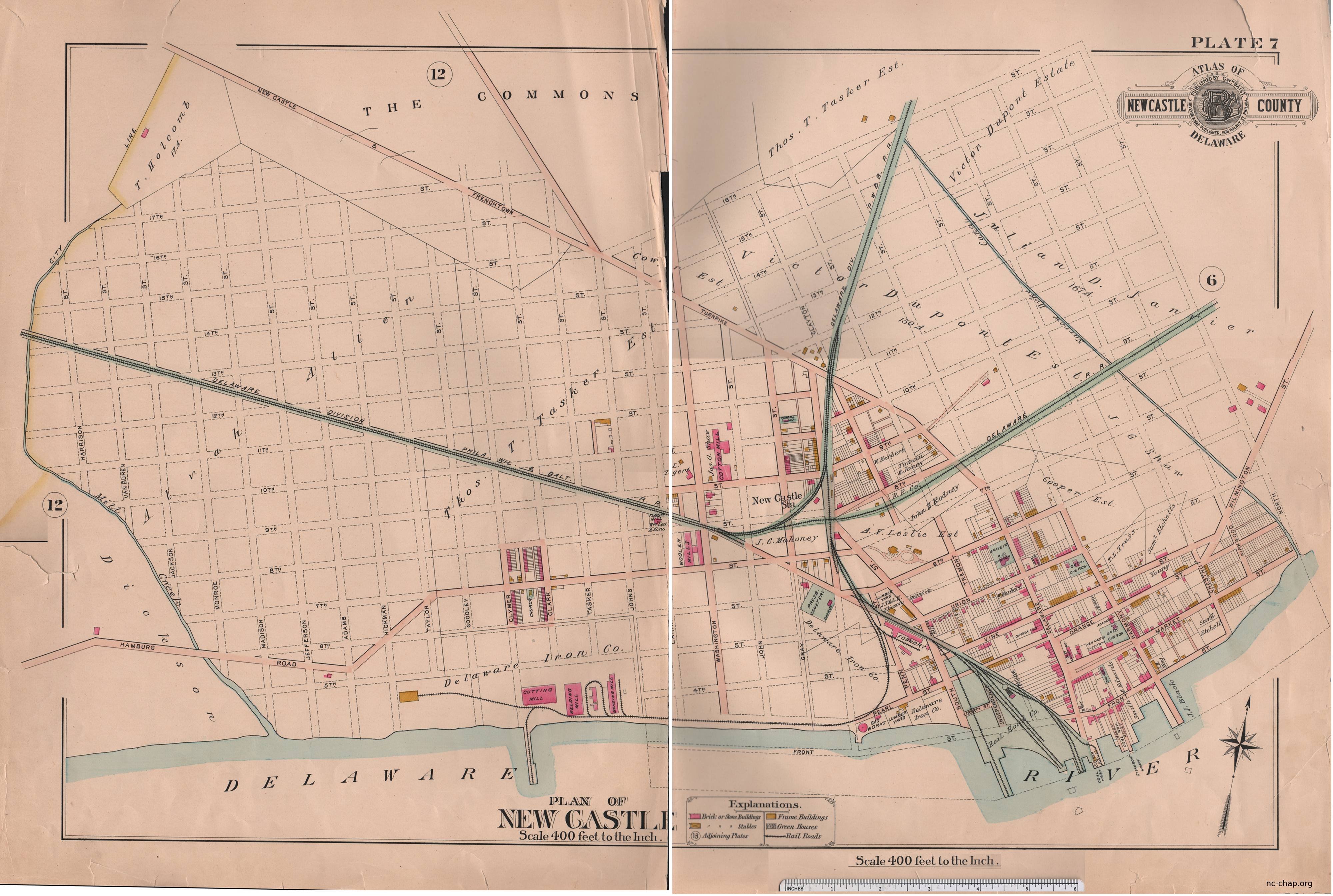
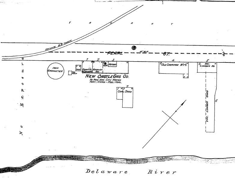 The 1885 Sanborn Co. fire insurance map (page 2)
and 1891 maps gives more details: the 'iron
gasometer' or gas tank or
gasholder is 10 ft diameter and within about 10 feet of a private railroad.
The layout of this railroad spur which ran to the Tasker Iron Works is shown on the
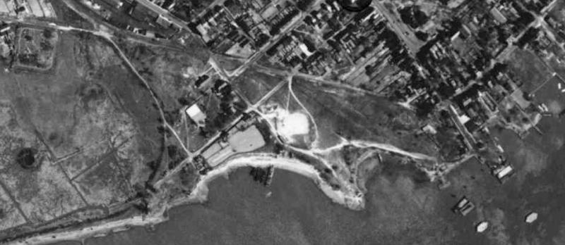
1906 USGS map. The outline of the roadbed
can be easily seen in a 1932 aerial photo.
The 1885 Sanborn Co. fire insurance map (page 2)
and 1891 maps gives more details: the 'iron
gasometer' or gas tank or
gasholder is 10 ft diameter and within about 10 feet of a private railroad.
The layout of this railroad spur which ran to the Tasker Iron Works is shown on the
1906 USGS map. The outline of the roadbed
can be easily seen in a 1932 aerial photo.

In the 1901, 1904 and 1907 Sanborn maps, the railroad (and Tasker Iron Works?) were gone, the 10' dia 10,000 cu. ft. tank was now 'not used' but it was " 500' to similar gasometer now used 22,000 cu ft.". So is the brick structure the c1900 gas tank? An 1899 image shows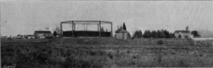 a steel frame on a mound in the marsh near the Lesley Mansion
with tank-like object within the frame.
The ~30 ft circular brick structure is about 700 feet away from the site of the iron tank, not 500 ft. If the heights of the
two tanks were the same, from πr2h the new tank would have 30 times the capacity, not 2.5 times.
and is certainly not similar to an iron tank. However, it would be very reasonable for the structure to have been a
telescoping
gasometer with a water base.
Large brick gasometers certainly existed. One built in Providence, RI in 1877 was 7 stories high.
a steel frame on a mound in the marsh near the Lesley Mansion
with tank-like object within the frame.
The ~30 ft circular brick structure is about 700 feet away from the site of the iron tank, not 500 ft. If the heights of the
two tanks were the same, from πr2h the new tank would have 30 times the capacity, not 2.5 times.
and is certainly not similar to an iron tank. However, it would be very reasonable for the structure to have been a
telescoping
gasometer with a water base.
Large brick gasometers certainly existed. One built in Providence, RI in 1877 was 7 stories high.
Gas lighting was invented long before coming to New Castle. It first came to America in 1816 in Baltimore by the predecessor to the Baltimore Gas & Electric Co. and 20 years later to Philadelphia (1836).
A 50 ft dia. brick gasholder in Rhode Island was adjacent to a cotton mill. The historic listing states that "Gasworks were commonly associated with large-scale textile mills of the nineteenth century." Did the New Castle gas co also serve the nearby Triton cotton mill and Tasker's steel mill in addition to providing city lights?
An 1896 monograph on The Chemistry of Gas Manufacture states that in the US illuminating gas was largely made from decomposition of coal or action of steam on incandescent carbon (water gas). The former source yields primarily methane, hydrogen and carbon monoxide(!), with tar as a byproduct, the latter yields primarily hydrogen (C + H20 -> CO + H2) There is a tar pump shown on the map for New Castle Gas. Tar can apparently be burned. Was the pump used to add tar as a partial fuel source in heating the retort, or was the tar pumped into the marsh or river or the immediately adjacent well?
DNREC lists New Castle Gas Co (DE 167) as a Hazardous Substance Control Act facility A report places the site at the border of the Presbyterian Cemetary and Brosius Eliason. It is not clear whether the lat/long is inaccurate or there is some evidence of the gas plant or dump being at that site or that the DNREC field investigator came at high tide and did not want to get wet feet.
Dick Aplebee recalls being warned to keep away from the gas tank as a child; Don Reese recalls hearing the tank is deep and full of fish. Carl Witt says there was another tank by the boathouse made of metal, and that you can still see its foundation outline at certain times of the year.
 But would a gas tank be brick? Approaching it from the Gambacorta parking lot, you can see the
mound is actually a water filled hollow brick cylinder ~30 feet dia, 8 feet above water level, and
currently 6-10 feet water depth. The 6 course thick brick wall is surrounded
by a mound of dirt. Photo by drone by Bruce Burk.
But would a gas tank be brick? Approaching it from the Gambacorta parking lot, you can see the
mound is actually a water filled hollow brick cylinder ~30 feet dia, 8 feet above water level, and
currently 6-10 feet water depth. The 6 course thick brick wall is surrounded
by a mound of dirt. Photo by drone by Bruce Burk.
When was the gas company built?
Where was the plant?
How was gas made? Do toxic chemicals remain?
Was the big brick thing really a gas tank? When was it built?
According to Scharf(1888) the plant was founded in 1857, and according to DNREC was acquired by .... Gas and closed in 1917.
 An overlay of the Beers 1868 atlas over a modern aerial photo shows that the gas plant was along the river
at the end of what is now Battery Park.
Shown are a round tank and rectangular building. The map shows nothing in
the adjacent marsh other than (planned?) roads.
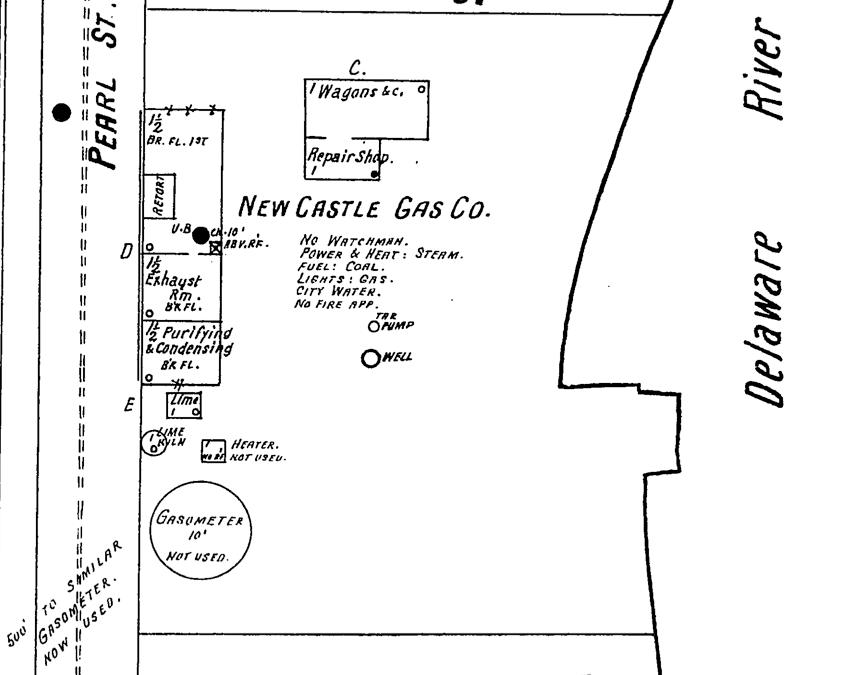
The 1885 Sanborn Co. fire insurance map (page 2)
and 1891 maps gives more details: the 'iron
gasometer' or gas tank or
gasholder is 10 ft diameter and within about 10 feet of a private railroad.
The layout of this railroad spur which ran to the Tasker Iron Works is shown on the
1906 USGS map. The outline of the roadbed
can be easily seen in a 1932 aerial photo.
An overlay of the Beers 1868 atlas over a modern aerial photo shows that the gas plant was along the river
at the end of what is now Battery Park.
Shown are a round tank and rectangular building. The map shows nothing in
the adjacent marsh other than (planned?) roads.
The 1885 Sanborn Co. fire insurance map (page 2)
and 1891 maps gives more details: the 'iron
gasometer' or gas tank or
gasholder is 10 ft diameter and within about 10 feet of a private railroad.
The layout of this railroad spur which ran to the Tasker Iron Works is shown on the
1906 USGS map. The outline of the roadbed
can be easily seen in a 1932 aerial photo.
In the 1901, 1904 and 1907 Sanborn maps, the railroad (and Tasker Iron Works?) were gone, the 10' dia 10,000 cu. ft. tank was now 'not used' but it was " 500' to similar gasometer now used 22,000 cu ft.". So is the brick structure the c1900 gas tank? An 1899 image shows
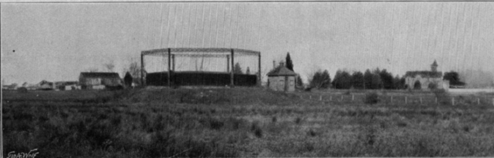 a steel frame on a mound in the marsh near the Lesley Mansion
with tank-like object within the frame.
The ~30 ft circular brick structure is about 700 feet away from the site of the iron tank, not 500 ft. If the heights of the
two tanks were the same, from πr2h the new tank would have 30 times the capacity, not 2.5 times.
and is certainly not similar to an iron tank. However, it would be very reasonable for the structure to have been a
telescoping
gasometer with a water base.
Large brick gasometers certainly existed. One built in Providence, RI in 1877 was 7 stories high.
a steel frame on a mound in the marsh near the Lesley Mansion
with tank-like object within the frame.
The ~30 ft circular brick structure is about 700 feet away from the site of the iron tank, not 500 ft. If the heights of the
two tanks were the same, from πr2h the new tank would have 30 times the capacity, not 2.5 times.
and is certainly not similar to an iron tank. However, it would be very reasonable for the structure to have been a
telescoping
gasometer with a water base.
Large brick gasometers certainly existed. One built in Providence, RI in 1877 was 7 stories high.
Gas lighting was invented long before coming to New Castle. It first came to America in 1816 in Baltimore by the predecessor to the Baltimore Gas & Electric Co. and 20 years later to Philadelphia (1836).
A 50 ft dia. brick gasholder in Rhode Island was adjacent to a cotton mill. The historic listing states that "Gasworks were commonly associated with large-scale textile mills of the nineteenth century." Did the New Castle gas co also serve the nearby Triton cotton mill and Tasker's steel mill in addition to providing city lights?
An 1896 monograph on The Chemistry of Gas Manufacture states that in the US illuminating gas was largely made from decomposition of coal or action of steam on incandescent carbon (water gas). The former source yields primarily methane, hydrogen and carbon monoxide(!), with tar as a byproduct, the latter yields primarily hydrogen (C + H20 -> CO + H2) There is a tar pump shown on the map for New Castle Gas. Tar can apparently be burned. Was the pump used to add tar as a partial fuel source in heating the retort, or was the tar pumped into the marsh or river or the immediately adjacent well?
DNREC lists New Castle Gas Co (DE 167) as a Hazardous Substance Control Act facility A report places the site at the border of the Presbyterian Cemetary and Brosius Eliason. It is not clear whether the lat/long is inaccurate or there is some evidence of the gas plant or dump being at that site or that the DNREC field investigator came at high tide and did not want to get wet feet.